Self-Guided Hike to Mt. Greben from Vermosh
– Explore Albania’s northernmost valley, where forests, pastures, and snow-fed streams converge
– Hike to the summit of Maja e Grebenit for panoramic views across Albania and Montenegro
– Enjoy a steady, moderate ascent through forests and wildflower-filled meadows
– Discover the untouched beauty of Vermosh, far from the tourist radar
– Hike self-guided along a quiet trail with nature as your only companion
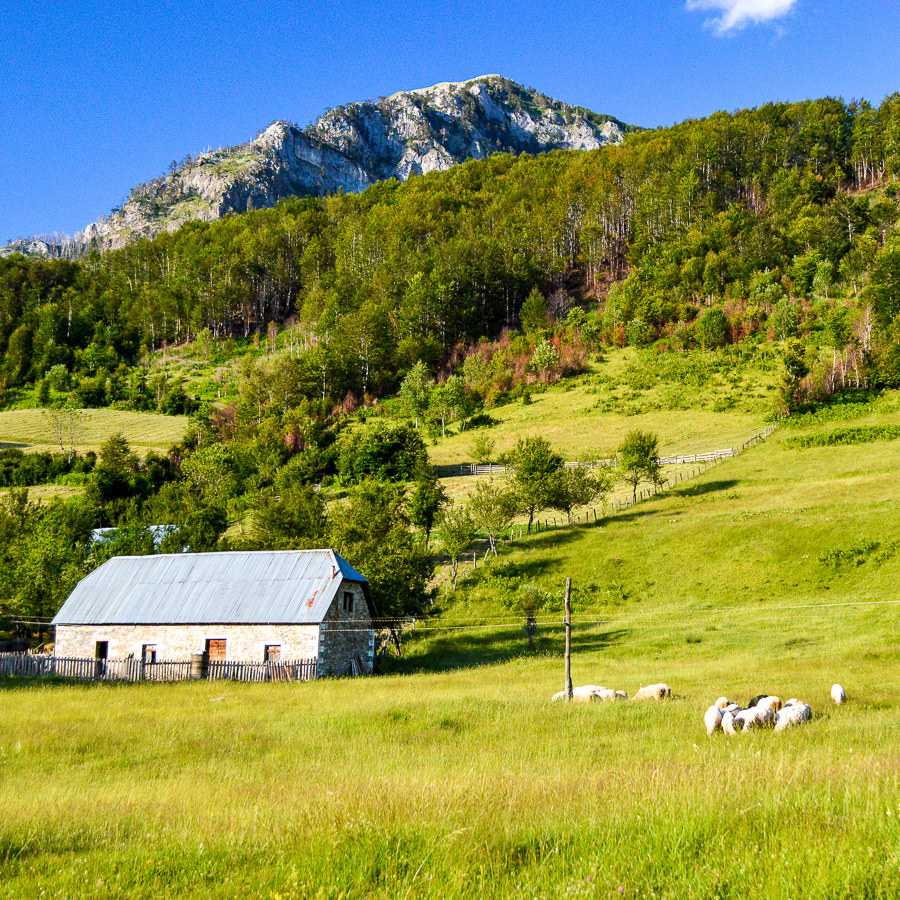
Located in the northernmost tip of Albania at 1000 meters above sea level, the village of Vermosh is surrounded by one of the most diverse and scenic landscapes in the Albanian Alps. The valley opens wide beneath gently rising mountains, with rich forest cover, alpine pastures, hidden caves, and streams fed by snowmelt. The Vermoshi River, which flows northward into Montenegro and eventually the Danube, adds to the region’s lushness. This relatively gentle but panoramic trail leads hikers through forested slopes and onto open highlands, culminating in expansive views from the summit of Maja Grebenit.
The hike begins in Vermosh and heads southwest on a gradually ascending path. The first part of the trail rises gently through pastures before entering the forest. As the trail gains altitude, the canopy opens occasionally to offer views back across the valley.
The trail remains clear and well-defined, winding steadily upward until it emerges into a wide alpine meadow, a scenic resting spot surrounded by silence and open views.
Reaching the top of Maja e Grebenit, you’re rewarded with panoramic vistas over the Vermosh Valley and the surrounding highlands, with layers of peaks stretching into both Albania and Montenegro.
The descent retraces the same path. It winds downhill, returning to the pastures above Vermosh and ultimately back to the village itself.
- Hiking Grade: Moderate
- Technical Difficulty: T2
- Total ascent: 800 m
- Total descent 800 m
- Distance: 11 km
- Time of the hike: 5 hours (Hiking time without breaks)
The price includes:
- Emergency telephone support during the hike
- Road Book App with detailed information and route descriptions in English
The price does not include:
- Other costs and services not mentioned in the program
- Guide
- Meals
- Transportation
- Any type of Insurance
This trail starts and ends in the village of Vermosh in the Albanian Alps.
Orientation:
To assist you, we provide a detailed information package, including route descriptions, digital maps and information about transportation options. All this will be available in a dedicated mobile app, which you can download to your smartphone before your adventure.
While most hiking trails are signed, some markings may be unclear or difficult to see. Certain sections might not be well-marked, and poor weather can make navigation more challenging. Good navigation skills are necessary to ensure a safe and enjoyable experience.
Hiking Time, Grade and Technical Difficulty:
Our tour descriptions give detailed information about terrain, technical difficulty, estimated activity times, ascent/descent in meters and distance in kilometres. We kindly ask you to read these very carefully and consider them while choosing your tour.
The estimated difficulty of hikes is given in the SAC scale, starting from T1 to T6. These grades are guidelines that must always be used in conjunction with your own experience, intuition and careful judgment. Explanations for the difficulty scale can be found here.
Estimated hiking times are given for each day. These times do vary according to the day’s weather conditions and your fitness levels. These times do not include times taken for meals and breaks. The hiking times are all calculated in accordance with the Albanian national standard for hiking trails, which is based on the Swiss Alpine Club adaptation of the DIN44366 standard.
General Information:
- Confirmation will be sent within 48 hours of booking
- Not wheelchair or stroller accessible
- Not recommended for pregnant travellers
- Not recommended for travellers with heart problems or other serious medical conditions
- Travelers should have a moderate physical fitness level
- For any other request or question, please write to us here
Free cancellation at any time before app download. Once the app has been downloaded, cancellations are no longer possible.