Self-Guided Hike to Mt. Vajusha in Lëpushë
– Ascend to a quiet summit above Lëpushë
– Enjoy dramatic views over the Albania–Montenegro border from a rarely visited peak
– Feel the shift in terrain as you climb: diverse, wild, and ever-changing
– Hike self-guided: a rewarding challenge without the crowds
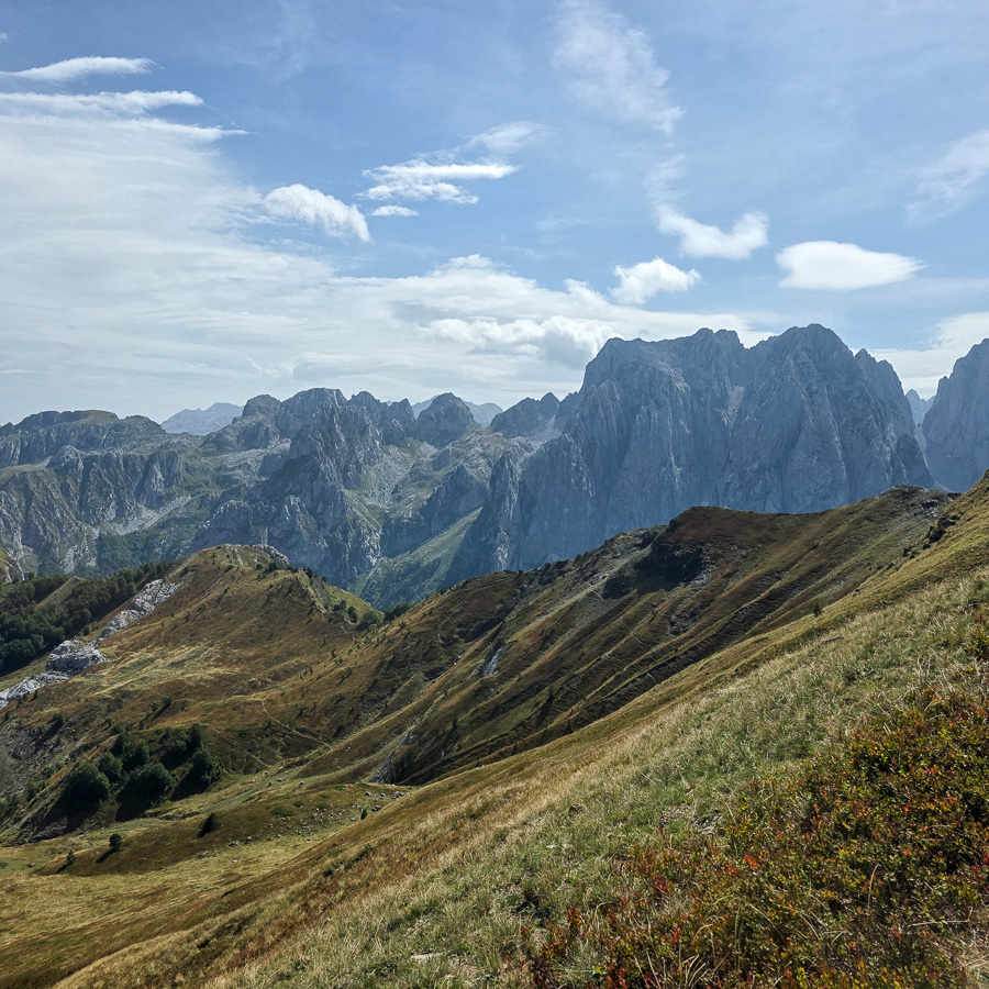
Set deep in the heart of the Kelmend region, this summit above Lëpushë offers one of the most commanding viewpoints in the Albanian Alps. The trail leads to a high vantage point at 2059 meters, from which you can see across vast sections of the Albania–Montenegro border, with sharp ridgelines, deep valleys, and open alpine slopes stretching in all directions. The area is known for its natural diversity: thick forests at the base give way to open meadows and exposed rock as you gain altitude. This route is especially rewarding for those seeking wide views and a full sense of elevation gain without technical terrain.
The hike begins from the village of Lëpushë and heads south-east, ascending steadily into a forest of beech and pine. This first section provides a shaded and gradual climb, with the trail surrounded by dense vegetation.
At around 1650 meters, the forest begins to thin and the landscape opens up. From here, the trail continues southward along more exposed slopes, moving through scattered alpine vegetation and patches of open ground. The incline becomes more sustained, but the trail remains clear and easy to follow.
As you approach the summit at 2059 meters, the views become increasingly dramatic. The summit is a prime spot to pause and take in the vastness of the Accursed Mountains and the remote beauty of the highlands.
After a break at the summit, the descent follows the same trail, offering a relaxed return to Lëpushë with the added benefit of looking back over the valley from a new angle.
- Hiking Grade: Moderate
- Technical Difficulty: T2
- Total ascent: 850 m
- Total descent 850 m
- Distance: 11 km
- Time of the hike: 5 hours (Hiking time without breaks)
The price includes:
- Emergency telephone support during the hike
- Road Book App with detailed information and route descriptions in English
The price does not include:
- Other costs and services not mentioned in the program
- Guide
- Meals
- Transportation
- Any type of Insurance
This trail starts and ends in the village of Lëpushë in the Albanian Alps.
Orientation:
To assist you, we provide a detailed information package, including route descriptions, digital maps and information about transportation options. All this will be available in a dedicated mobile app, which you can download to your smartphone before your adventure.
While most hiking trails are signed, some markings may be unclear or difficult to see. Certain sections might not be well-marked, and poor weather can make navigation more challenging. Good navigation skills are necessary to ensure a safe and enjoyable experience.
Hiking Time, Grade and Technical Difficulty:
Our tour descriptions give detailed information about terrain, technical difficulty, estimated activity times, ascent/descent in meters and distance in kilometres. We kindly ask you to read these very carefully and consider them while choosing your tour.
The estimated difficulty of hikes is given in the SAC scale, starting from T1 to T6. These grades are guidelines that must always be used in conjunction with your own experience, intuition and careful judgment. Explanations for the difficulty scale can be found here.
Estimated hiking times are given for each day. These times do vary according to the day’s weather conditions and your fitness levels. These times do not include times taken for meals and breaks. The hiking times are all calculated in accordance with the Albanian national standard for hiking trails, which is based on the Swiss Alpine Club adaptation of the DIN44366 standard.
General Information:
- Confirmation will be sent within 48 hours of booking
- Not wheelchair or stroller accessible
- Not recommended for pregnant travellers
- Not recommended for travellers with heart problems or other serious medical conditions
- Travelers should have a moderate physical fitness level
- For any other request or question, please write to us here
Free cancellation at any time before app download. Once the app has been downloaded, cancellations are no longer possible.