Self-Guided Hike in the surroundings of Valbona
– Hike to Bregu i Rrethit, a peaceful alpine meadow perched above the Valbonë Valley
– Enjoy panoramic views of jagged limestone peaks and glacial basins from 1600 meters
– Ascend steadily through beech forest and open clearings, following the directions of your self-guided navigation app
– Take in a quieter side of the Alps, away from the popular paths
– Return via a different route for a new perspective on the landscape below
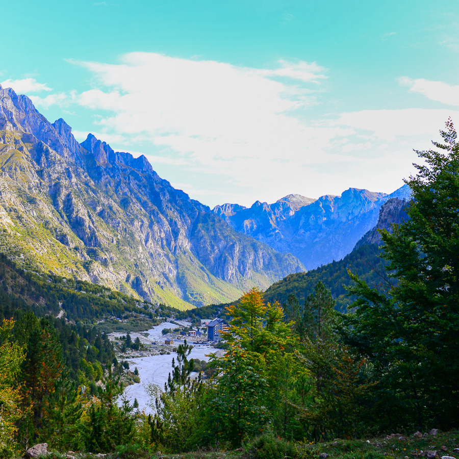
“Bregu i Rrethit” is a high alpine meadow located on the North-Western side of Valbonë Valley. Set above the tree line at approximately 1,600 meters, it overlooks the wide glacial basin of Valbona and provides panoramic views of the dramatic peaks of Grykët e Hapëta and the jagged limestone ridges of the Zhaborre Range. The meadow at the upper part of the trail is a quiet, open space, surrounded by alpine vegetation and shaded by patches of beech forest. It’s a less frequented spot, which makes it a great choice for those looking for a scenic yet peaceful hike.
The hike begins in the village of Valbonë, heading North on a well-marked and visible trail. The path quickly leaves the valley, rising gently at first through open meadows and scattered homes before entering a shaded section of beech forest. The steady ascent offers glimpses of the surrounding cliffs and occasional views back toward the village below.
As the trail climbs higher, the forest begins to thin, giving way to rocky slopes and clearings. After approximately 650 meters of elevation gain, you’ll reach the high alpine meadow known as Bregu i Rrethit.
This is a perfect place for a short rest or a photo break. After taking in the landscape, the return to Valbonë follows a new section of downhill trail, offering a different perspective on the valley and a relaxing descent through forest and meadow.
- Hiking Grade: Moderate
- Technical Difficulty: T3
- Total ascent: 650 m
- Total descent: 650 m
- Distance: 9 km
- Time of the hike: 4 hours (Hiking time without breaks)
The price includes:
- Emergency telephone support during the hike
- Road Book App with detailed information and route descriptions in English
The price does not include:
- Other costs and services not mentioned in the program
- Guide
- Meals
- Transportation
- Any type of Insurance
This trail starts and ends in the village of Valbona in the Albanian Alps.
Orientation:
To assist you, we provide a detailed information package, including route descriptions, digital maps and information about transportation options. All this will be available in a dedicated mobile app, which you can download to your smartphone before your adventure.
While most hiking trails are signed, some markings may be unclear or difficult to see. Certain sections might not be well-marked, and poor weather can make navigation more challenging. Good navigation skills are necessary to ensure a safe and enjoyable experience.
Hiking Time, Grade and Technical Difficulty:
Our tour descriptions give detailed information about terrain, technical difficulty, estimated activity times, ascent/descent in meters and distance in kilometres. We kindly ask you to read these very carefully and consider them while choosing your tour.
The estimated difficulty of hikes is given in the SAC scale, starting from T1 to T6. These grades are guidelines that must always be used in conjunction with your own experience, intuition and careful judgment. Explanations for the difficulty scale can be found here.
Estimated hiking times are given for each day. These times do vary according to the day’s weather conditions and your fitness levels. These times do not include times taken for meals and breaks. The hiking times are all calculated in accordance with the Albanian national standard for hiking trails, which is based on the Swiss Alpine Club adaptation of the DIN44366 standard.
General Information:
- Confirmation will be sent within 48 hours of booking
- Not wheelchair or stroller accessible
- Not recommended for pregnant travellers
- Not recommended for travellers with heart problems or other serious medical conditions
- Travelers should have a moderate physical fitness level
- For any other request or question, please write to us here
Free cancellation at any time before app download. Once the app has been downloaded, cancellations are no longer possible.